
Cook Islands seabed habitat management zones developed

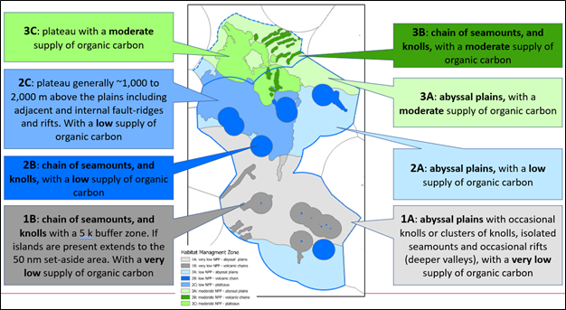
Level 1 habitat management zones
The Cook Islands Seabed Minerals Authority (SBMA) is pleased to announce the release of its seabed spatial model, the Level 1 seabed habitat management zones (HMZs).
The HMZs are groupings of different seabed habitats based on the best available information today. A seabed habitat is a particular seabed environment where specific groups of animal types have adapted and live as a result of specific seabed environmental conditions.
Level 1 means the areas have been categorised based on regional data and information. More detailed HMZs (termed Level 2 or Level 3) may be required in smaller seabed areas where future minerals harvesting is being seriously considered.
Currently, the Cook Islands does not have enough information yet to develop level 2 or 3 HMZs. The HMZs are adaptive, meaning they can be reviewed and changed as more information becomes available.
Exploration and scientific research are important as it will lead to more data and information to enable the Cook Islands to better understand and protect the Marae Moana.
SBMA presented the HMZs to a number of stakeholders, including: National Environment Service, Ministry of Marine Resources, Ministry of Foreign Affairs & Immigration, Ministry of Transport, Marae Moana Coordination Office, Infrastructure Cook Islands, Climate Change, Aronga Mana, Natural Heritage Trust, Te Ipukarea Society, Korero o te Orau, the Pacific Community, New Zealand National Institute of Water and Atmospheric Research, International Union for Conservation of Nature, CIC, Cobalt Seabed Resources and Moana Minerals. Their collective feedback improved the HMZs and was greatly appreciated.
The HMZs were defined over the Cook Islands exclusive economic zone, and also includes the seabed area covered in the Cook Islands extended continental shelf (ECS) submission to the Commission on the Limits of the Continental Shelf (CLCS). The CLCS has not yet determined the Cook Islands ECS submission, originally filed in 2009, and whether this extended continental shelf will be assigned to the Cook Islands.

Senior Knowledge Management Officer Rima Browne delivering HMZs presentation
“The development of the HMZs has been a long but worthwhile process” said Knowledge Management Director John Parianos. “We followed and adapted the approach taken for the Clarion Clipperton Zone, another place where the exploration of nodules is currently taking place. Then we presented the HMZs to some 20-odd expert groups from the Cook Islands and around the world, receiving excellent feedback and improving the results to where we are today”.
“Our HMZs were defined using two primary datasets” added Senior Knowledge Management Officer Rima Browne. “We used our recently published Cook Islands seabed geomorphology, as well as a model of net export carbon to the seabed. Net export of organic carbon is essentially how much food makes it from the surface of the sea to the seabed for the animals that live there”.

Geomorphology and net export of organic carbon were the two datasets used to define the level 1 HMZs.
The seabed geomorphology was categorised into: (A) abyssal plains; (B) seamounts and ridges; and the (C) Manihiki Plateau
The modelled net export of organic carbon was categorised as: (1) very low net primary productivity (NPP); (2) low NPP; or (3) moderate NPP.
There are in effect nine HMZ types based on the 3 main types of geomorphology times the 3 main defined levels of net export of organic carbon.
There are in effect nine types of HMZ based on the 3 main types of geomorphology times the 3 main defined levels of net export of organic carbon.
The HMZs will contribute towards the forthcoming Marae Moana Spatial Plan (MSP). Marine Spatial Plans enable development decisions to be made more accurately and are best practice internationally.
“To be an effective management tool for our Marae Moana it is important that the HMZs are both fit for purpose and easy to understand,” noted SBMA Commissioner Alex Herman, “We are really pleased with this Level 1 seabed spatial model as a first step to understanding and protecting our Marae Moana. Our country is 99.99% ocean and our seabed is an important part of it”
Further information on the HMZs can be found here
Queries may be directed to: [email protected]