
A ‘New’ Underwater Volcano: Rising from the Depths Near You!
The Seabed Minerals Authority (SBMA), in collaboration with other partners such as the National Institute of Water and Atmospheric Research (NIWA), University of California Santa Barbara, and Kiva Marine, recently went volcano hunting without a seabed mineral in sight. Keep reading if you want to find out why and how.
If new discoveries are your thing, then the Cook Islands deep-sea environment is currently an exciting place to work. Our scientists are these days dealing with a data “waterfall.” This is both in terms of new types of information and the sheer quantity of it. In the last few years, our scientists have pulled together a new framework of scientific information, especially regarding how we are learning about and managing the marine environment [Figure 1]. And now we are taking our first tentative steps in filling in this framework.
It is clear that deep-sea science is expensive to carry out. Even a single scientist needs a fully crewed and equipped ship to support them when they go out to collect the hard data needed to test their hypotheses. So, it is also usually important to have collaborators that you can rely on, and it is in this area that the Cook Islands is truly blessed. Scientists from around the world are joining us as we take these steps to better understand our Marae Moana. This is not a quick process; it is a marathon, not a sprint; but so far, we are making some great progress.
A fitting example of this is our recently completed ARTEX 2025 expedition. Late last year, SBMA scientists were sharing with others some of the details of a new seabed map when it was realized with some excitement that we might have something quite special about 100 kilometers south-east of Rarotonga… and if this proved to be the case, then we wanted to learn about it and then how to best protect it.
The seabed of the Cook Islands is made mostly of rocks formed from undersea volcanoes of different kinds. When we map the seabed in some detail, we discover a landscape of hills, valleys, and plains. Some volcanoes form massive mountains, others that look like pancakes, and others again that sprawl across the landscape. The tallest volcanoes reach above the waves and are often crowned with limestone reefs; of course, these are our islands.
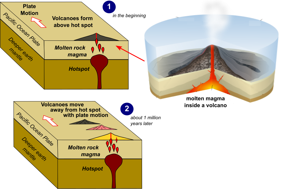
Figure 1: How volcanoes can form over hot spots
Adapted from: https://www.nps.gov/subjects/geology/plate-tectonics-hotspots.htm and https://en.wikipedia.org/wiki/Seamount
While most of these volcanoes are quite old, about 10, 20, 30, or even over 100 million years old, the islands of Rarotonga and Aitutaki are different, as both islands are made of a combination of older and younger volcanic rocks [Figure 2]. The younger rocks are much younger (well, to a geologist anyway), with lavas as young as “only” 1.2 million years old on Rarotonga. This is the main reason why Rarotonga at least has such large mountains compared to the other islands. Basically, there hasn’t been enough time for the rain and waves to erode all of the volcanic rock into the sea.
Some of the volcanoes in the Cook Islands (including Rarotonga) are believed to form from so-called “hot spots” deep in the earth. As the surface of the earth moves due to plate tectonics or continental drift, a string of volcanoes form above the hotspot (Figure 1), a little bit like what would happen if you moved your hand above the top of a candle… The Hawaiian Island chain is the best example of this, and experts like Dr Matthew Jackson, who is with the University of California at Santa Barbara, study these hot spots in the Cook Islands region.
Last year Matthew and his graduate student Yifan Du discovered that an underwater volcano (named “Tama”), about 60 km south-east of Rarotonga, is half the age of the younger rocks in Rarotonga. At about 670,000 years old, these are the youngest volcanic rocks yet discovered in our country. What the team noticed is that if you drew a line from Rarotonga through Tama and kept going, it looked like there could be more volcanoes further to the south-east, and using the hotspot model, these could be a lot younger and could maybe even be active today. At almost the right point here is another underwater volcano called “Pepe.”

Figure 2 The new bathymetric map of the volcanic chain south-southeast of Rarotonga
Note the data is shown here before processing, which will improve the quality further. The top map also compares the new information with the very low-resolution satellite bathymetry, which is all we have for ~80% of the Cook Islands today.
Now, first up, don’t worry; discovering this type of active volcanism in the Cook Islands is unlikely to affect you. The types of volcanoes found in our geological setting are not usually very explosive (they are just like the ones in Hawaii rather than those in Tonga or Indonesia), and ours are also several kilometres underwater. But secondly, due to the higher heat that might be near them at the seabed, there might just be a special marine environmental habitat present; maybe something quite different from what we expect elsewhere in the Cook Islands.
Well, once the team realised this situation was a possibility, we also realised pretty quickly that we didn’t have the capability right now to go and search the area to confirm if there was something there. So ... We filed the idea for another time.
But then, about six months later, we suddenly got an opportunity to do at least part of the work, and so with just a few days' notice, we quickly contacted the team and pulled together this mini expedition called ARTEX2025. The opportunity was that our locally based research ship, Kiva Marine’s M/V Anuanua Moana, had to leave harbour to make room for an incoming container ship.
This research ship already has the equipment on board to map the seabed. So instead of it simply standing off Rarotonga for two days waiting for the container ship to leave, we could use it to do some seabed mapping along the likely hotspot chain. And at the same time, we could collect a little water column information. This could set up scientists in the future to go and search and sample the seabed in detail to find out how old the volcanoes might be and if they happen to have any specific life there that would be best to protect.

Image Credit: Moana Minerals
L-R: Ngatupuna Kae (NES); Dr. John Parianos - Knowledge Management Director (SBMA); Edward Herman - Partnerships & Cooperations Director (SBMA); Keanu Harawira (NES Ranger)
ARTEX2025 is SBMA’s third research expedition in recent years, and the team has come together smoothly. Kiva provided the vessel, SBMA some staff and costs, NES sent scientists to observe, the University of California added technical commentary and guidance, and our friends at NIWA will again help in the data processing.
So, what have we learned so far? The new seabed mapping now shows in detail a line of volcanoes on the seabed south-east of Rarotonga (Figure 2). In addition to Tama and Pepe, there are smaller volcanic knolls along the line connecting them with Rarotonga and occurring further south-east again.
These may well have come from a volcanic hotspot based on their shape and location, but samples need to be taken in the future to properly check. Once fully processed and interpreted, our new seabed map should help any future scientists quickly go directly to the best points for this sampling. We also now have some water column conductivity and temperature data, but it also needs to be processed and compared to other parts of the Cook Islands to see if it is different in certain key areas.
So far, we have not seen any clear signs of volcanic activity, but then again, no one has yet had the chance to look carefully at the seabed and sample it.
Are you interested in learning more? All of the data from this research expedition will be made publicly available as soon as it is processed. Look on the SBMA webpage in the CSD data repository or contact us directly. And when the day comes, maybe you can be part of the next expedition to search for the younger and more active volcanoes?
References:
[1] Cook Islands deep Seabed EBMF & SEA https://www.sbma.gov.ck/ebmf-sea
[2] M G Jackson, S A Halldórsson, A Price, M D Kurz, J G Konter, A A P Koppers, J M D Day, Contrasting Old and Young Volcanism from Aitutaki, Cook Islands: Implications for the Origins of the Cook–Austral Volcanic Chain, Journal of Petrology, Volume 61, Issue 3, March 2020, egaa037, https://doi.org/10.1093/petrology/egaa037
For further information or media queries, please contact: [email protected]